


Burns Voting District, Smith County, Mississippi
About
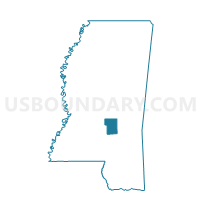
Outline

Summary
| Unique Area Identifier | 606678 |
| Name | Burns Voting District |
| County | Smith County |
| State | Mississippi |
| Area (square miles) | 31.00 |
| Land Area (square miles) | 30.99 |
| Water Area (square miles) | 0.01 |
| % of Land Area | 99.96 |
| % of Water Area | 0.04 |
| Latitude of the Internal Point | 32.17333440 |
| Longtitude of the Internal Point | -89.56235840 |
Maps


Graphs
Select a template below for downloading or customizing gragh for Burns Voting District, Smith County, Mississippi


Neighbors
Neighoring Voting District (by Name) Neighboring Voting District on the Map
- Homewood Voting District, Scott County, MS
- Lorena-Spinola Voting District, Smith County, MS
- North Raleigh Voting District, Smith County, MS
- Polkville 77 Voting District, Smith County, MS
- Polkville 79 Voting District, Smith County, MS
- Pulaski Voting District, Scott County, MS
Top 10 Neighboring County Subdivision (by Population) Neighboring County Subdivision on the Map
- District 3, Scott County, MS (6,119)
- District 2, Scott County, MS (5,283)
- District 4, Smith County, MS (3,602)
- District 5, Smith County, MS (3,322)
Top 10 Neighboring Unified School District (by Population) Neighboring Unified School District on the Map
- Scott County School District, MS (19,782)
- Smith County School District, MS (16,491)
- Forest Municipal School District, MS (8,482)
Top 10 Neighboring State Legislative District Lower Chamber (by Population) Neighboring State Legislative District Lower Chamber on the Map
- State House District 77, MS (24,592)
- State House District 79, MS (22,592)
- State House District 75, MS (22,303)